


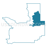
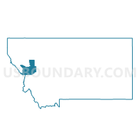
Precinct 3, Missoula County, Montana
About
Outline

Summary
| Unique Area Identifier | 612170 |
| Name | Precinct 3 |
| County | Missoula County |
| State | Montana |
| Area (square miles) | 309.77 |
| Land Area (square miles) | 302.99 |
| Water Area (square miles) | 6.78 |
| % of Land Area | 97.81 |
| % of Water Area | 2.19 |
| Latitude of the Internal Point | 47.20315730 |
| Longtitude of the Internal Point | -113.57556860 |
Maps

Graphs
Select a template below for downloading or customizing gragh for Precinct 3, Missoula County, Montana


Neighbors
Neighoring Voting District (by Name) Neighboring Voting District on the Map
- Precinct 1, Missoula County, MT
- Precinct 17, Missoula County, MT
- Precinct 2, Missoula County, MT
- Precinct 5, Missoula County, MT
Top 10 Neighboring County Subdivision (by Population) Neighboring County Subdivision on the Map
- Missoula CCD, Missoula County, MT (82,600)
- Seeley Lake-Blackfoot Valley CCD, Missoula County, MT (3,760)
- Flathead Reservation CCD, Missoula County, MT (880)
- Helmville CCD, Powell County, MT (501)
Top 10 Neighboring Place (by Population) Neighboring Place on the Map
Top 10 Neighboring Elementary School District (by Population) Neighboring Elementary School District on the Map
- Arlee Elementary School District, MT (2,530)
- Seeley Lake Elementary School District, MT (2,054)
- Swan Valley Elementary School District, MT (551)
- Ovando Elementary School District, MT (253)
- Sunset Elementary School District, MT (212)
Top 10 Neighboring Secondary School District (by Population) Neighboring Secondary School District on the Map
- Missoula High School District, MT (100,417)
- Powell County High School District, MT (7,226)
- Arlee High School District, MT (2,530)
Top 10 Neighboring State Legislative District Lower Chamber (by Population) Neighboring State Legislative District Lower Chamber on the Map
- State House District 99, MT (11,785)
- State House District 15, MT (9,595)
- State House District 92, MT (9,208)
- State House District 17, MT (8,272)
Top 10 Neighboring State Legislative District Upper Chamber (by Population) Neighboring State Legislative District Upper Chamber on the Map
- State Senate District 50, MT (21,523)
- State Senate District 8, MT (19,081)
- State Senate District 46, MT (18,643)
- State Senate District 9, MT (18,437)
Top 10 Neighboring 111th Congressional District (by Population) Neighboring 111th Congressional District on the Map
Top 10 Neighboring Census Tract (by Population) Neighboring Census Tract on the Map
- Census Tract 14, Missoula County, MT (6,750)
- Census Tract 18, Missoula County, MT (4,640)
- Census Tract 1, Powell County, MT (1,431)